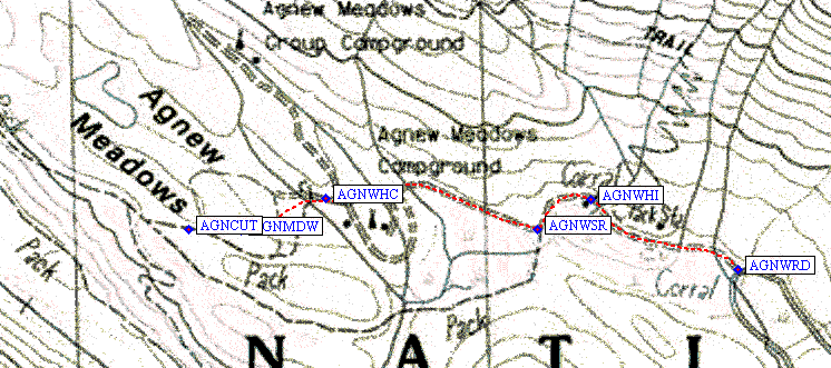
Follow the directions above to waypoint AGNWRD and go north where the paved road does a hairpin and heads south. The dirt Agnew Meadow Road leads to Agnew Meadows Campground and the Shadow Lake/River Trail (waypoint AGNWSR) or High Trail (waypoint AGNWHI) trailheads. There are campsites here, including horse camps and group camps, but they are a minimum of $16/night. This campground tends to be less full than the others further south because there are no views and more bugs. Climbers would be well advised to camp up on Minaret Summit for better acclimatization and fewer mosquitoes.

This area can be confusing after dark: Go past the pack station, and the first trailhead is what you want if you're going north on the Pacific Crest Trail to Agnew Pass and Summit Lake. Most climbers will continue to the SECOND trailhead, where signs say River Trail / Shadow Lake / PCT South. In daylight the second lot will be a gravel parking loop at the edge of a meadow, near a small stream. Some have 'stealth camped' here, but it might be best to walk into the trees since the campground fee was $16/night and with that kind of money at stake they may come looking for you. Both trailheads have two-hole restrooms and working water spigots, as does the campground.
The trailhead for Shadow Lake leads to the River Trail, leaving the cars going DOWNHILL to the south, then angling west UPCANYON to where the PCT turns south again while the Shadow Lake trail continues northwest. There is a trick for cutting off a bit of distance and up/down if you're clever: Head on down the road toward the campground, do NOT go to the Group Camp, walk past the fee board for the Horse Camp and look to the right for a Road Closed sign in the furthest north horse campsite (waypoint AGNWHC). Beyond the Road Closed sign a faint use trail crosses a stream and leads west across Agnew Meadow proper to intersect a pack trail (waypoint AGNCUT) which then intersects with the main trail. It's easy to find this route on the way in, harder on the way out (so look backwards every so often when going in). There are cut logs across the trail near the intersection, but in general the trail (when returning to the trailhead) sidehills up out of the canyon - and when it reaches the crest and is no longer on the sidehill, look hard for trails branching left.