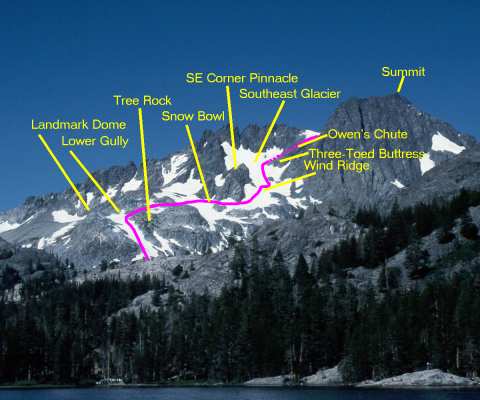
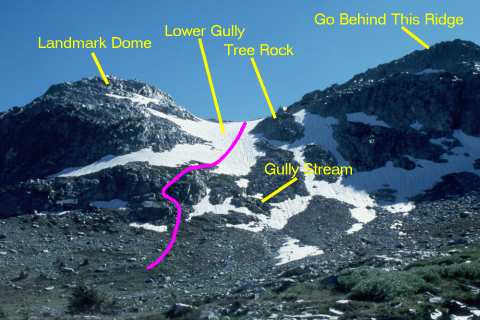
I would rate it (conservatively) as 95% second-class snow and rock. There are a couple of spots of steep (>45°) snow, especially that wind ridge as you get onto the Southeast Glacier, and Owen's Chute can be done either on solid second-class talus and scree, or up a couple of hops of low third-class breaks.
The view from Shadow Lake provides a good vantage point for looking at the lower and middle parts of the climb. Important landmarks are the dome to the left (south) of the desired lower gully, the "tree rock" about 1/2 to 2/3 the way up the gully, the 
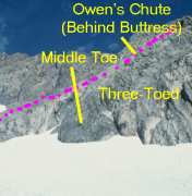
pinnacle at the corner of the Southeast Glacier, and the "three-toed buttress" which marks Owen's Chute.

The next photo will show the very bottom of the climb, but once you are in the lower gully, go almost to the top before turning right over the ridge. If you turn at the "tree rock", you end up in some nasty 3rd and 4th class cliffs, as Yehuda and I did in 1998. Going all the way to the top (or nearly so) leaves you an easy 2nd-class scramble over the rocky outcrops to the snow bowl.

You then contour around the snow bowl, staying low enough not to risk a fall into the gap between the snow and rock, and to find a relatively-less-steep point to cross the wind ridge which diagonals down from the pinnacle.

You then turn up the Southeast Glacier and continue up past all three "toes" of the three-toed buttress before making a sharp right turn (almost a U-turn) into Owen's Chute, which is hidden behind the buttress in this view.


Standing in the glacial valley above Ediza Lake, where the exit stream braids its way among the granite outcrops, you will get this foreshortened view of the lower gully. The features are identified as on the previous view, and it is obvious from this view that you can get confused about where the "top" of the gully is, due to the varying slope of the snow, which is steeper in the lower stretches and flattens out a bit after a ridge about halfway up.

The landmark to avoid is the "tree rock". Keep going well above this and go above/behind the ridge at the upper right in this photo.

The stream which exits the gully lobbies for starting the climb either to the left (as we did) or to the right of the gully. You could also go a bit farther to the left and dodge some of that lower outcrop, but it's just a scramble, nothing more, so is easily and quickly overcome.

 
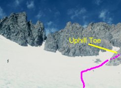
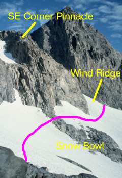
Once you walk over the rocks, you will see this snow bowl. This year, there was a tongue of rock sticking down from the pinnacle at the corner of the glacier, but it was narrow enough at the top to walk across without removing crampons.

The process here is simple...contour around the bowl, staying well below the snow/rock line, and then climb over the wind ridge at the far side of the bowl.

The wind ridge is the only place the snow is really steep, clearly more than 45°, so a bit more caution is advisable for that short pitch. Once over it, you are onto the Southeast Glacier, proper, and the climbing is again easy on moderate-angle suncupped snow.

 
As you leave the large rock outcrop at the snout of the Southeast Glacier, you see its expanse spread out in front of you. Immediately above you and to the right are Secor's chute and a steep, narrow, dead-end chute full of really slick slate. (I know whereof I speak from my 1994 attempt which ended in that chute.)

Secor's chute is blocky but doable, although the snow headwall above it can be intimidating, depending on how the winter storms blew in and how steep the slope is on the snow.

Owen's Chute, just beyond the uphill "toe" of the "three-toed" buttress, is the easiest route to the upper bowl. If you stay to the right of the rock outcrop in the middle of Owen's Chute, it is moderate class 2 talus and scree. To the left, there are a couple of spots of not-particularly-difficult third-class rock, so it works either way.


When you reach this point, you are really in the home stretch. You have about 500 vertical feet to climb, and on the rock, it is an easy stretch, save for the fact that you have to watch for the wandering oxygen molecules and snag the few that meander by!

From the top of Owen's Chute, the route is quite straightforward. You cross the lower snow field, which is at a shallow enough angle not to require crampons, then skirt the left edge of the upper, steeper snow field until you reach the summit ridge. A couple of hundred feet of basically horizontal scrambling along the ridge take you to the summit, proper. Do mind the exposure to the north, though. It would be a quick but painful trip down if you went over it to that side.

What appears to be the summit is actually a bump on the upper slope which sticks out far enough to be tantalizing, but is a bit lower than the ridge and true summit, which are obscured behind it in this view. From this point, it took us about 45 minutes to reach the summit on an absolutely gorgeous day.

This annotated image, made up of USGS orthophotoquads, shows an aerial view of the whole climb. Obviously, the USGS photos were taken in a somewhat drier year than either 1998 or 1999, since there is quite a bit more exposed rock than there has been lately.

The image links to a medium-sized (600-pixel) copy of the image. There is an even larger, 1500 x 900 pixel, image available if you have the patience to download it.